

Blood, Sweat and yes, tears went into climbing Dore Pass in Fiordland, New Zealand. One of the most advanced climbs in Fiordland, we planned it last-minute. I did absolutely no planning for Dore Pass; But they say the best plan is no plan, right?
Thankfully for this trip I had a partner in crime, who did all the ‘research’. Now, when I say research, I mean read other articles and blogs other walkers had written about the climb. As it is not an official Department of Conservation Route you can’t find much about it online – other than danger warnings and advising of advanced alpine skills. But danger is half of the thrill right? And god knows I love a challenge…. I just didn’t realise how challenging this would be.
Dore Pass is definitely an advanced climb. Yes you may roll your eyes at this (just like I did) but seriously guys, advanced really does mean advanced. If you know how to read a map – and remember to take one with you – find a trail when you lose it again, have experience carrying heavy packs in alpine conditions, bush bashing (yep, I giggled when i first heard this term too) then you will be fine. This track is not for the lonely. Do this in pairs guys and seriously, pay that wee bit of money to hire an EPIRB (Emergency Position Indicating Radio Beacon) it’s so easy for things to go wrong or turn nasty, especially in Fiordland.
And for the final lecture, tell someone reliable where you are going and when to panic (or expect you back). When you are travelling, like me, it is so easy to forget about letting people know where you are. Especially when you travel alone. But imagine something did happen to you. Realistically, how long do you think it would take someone to ring the alarm? For me it would be more than a week and by that point, things would not be good. So yes, leave your crazy intentions with someone you trust.
I’ll stop lecturing now and start telling you the tale behind the crazy climb of Dore Pass. The hardest mountain I have ever had the pleasure of climbing.
Climbing Dore Pass
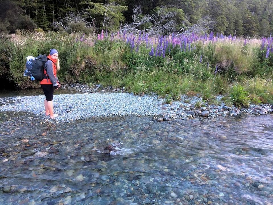
Hitting the road a little later than planned. – thanks work – We drove down the Milford Road a bit further from Eglinton Flats and parked in a (tiny) car park you’d miss unless specifically looking for it. Parked up in time for the sun beginning to dip below the mountains it was time to hustle. Shoving last-minute items (mainly food) into our backpacks, being sensible and leaving a note on the dashboard of the car, working out the best way to shimmy down onto the river bed and mentally preparing ourselves for the cold river crossing. We were ready to go.
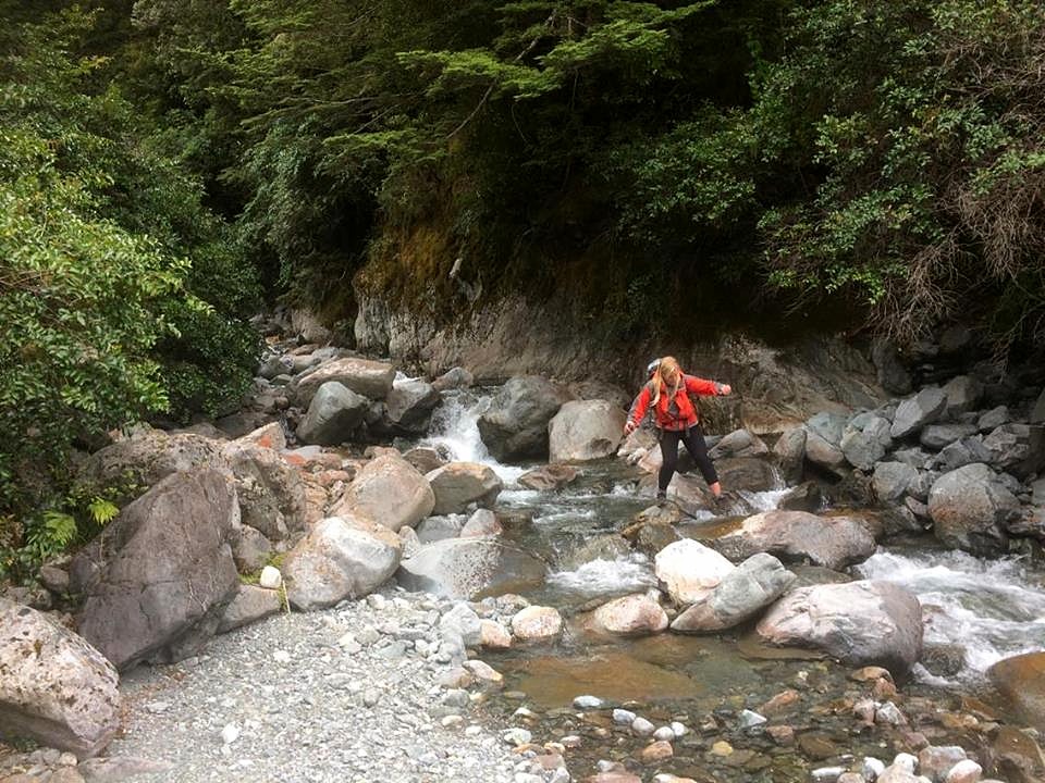
Crossing the river was the least of our challenges ahead but never the less, it was a hard challenge to start on. Do I cross in my shoes or go bare feet? Well, you have to cross at least two stretches of river, the first is shallow and short. So I did it in bare feet. WOW it was cold and sore, I was not doing that again.
Walking a while down the river through the beautiful Lupins we decided the best way to Dore Pass was crossing one of the widest stretches of river, in our shoes. Still cold, but the crossing was one hundred times easier and safer in shoes. Although the Eglinton river looks shallow, it actually reached up to my thigh – and this was low tide! – and it was fast. Successfully across the river, surviving the burning cold water, it was time to walk (in wet shoes) into the bush-line.
Watching the light turn into a haze, the mountains slowly becoming silhouettes and the full moon becoming brighter in the hazy orange sky we quickly stumbled across the moorland into the bush line. There are no marks showing the right place to enter the bush line but hit it around 200 metres from the V of the valley above and you should be on the right track. Orange markers are what you are looking for. They are often shaped as triangles and not to be confused with the pink and blue dotted around the bush which are trap lines and will lead you on an adventure through the bush (trust me!).
Starting our hike pretty late we followed the path into the woods – once we eventually found it – and scouted out a place to pitch the tent for the night.
The next day was to be the most challenging but the most rewarding…
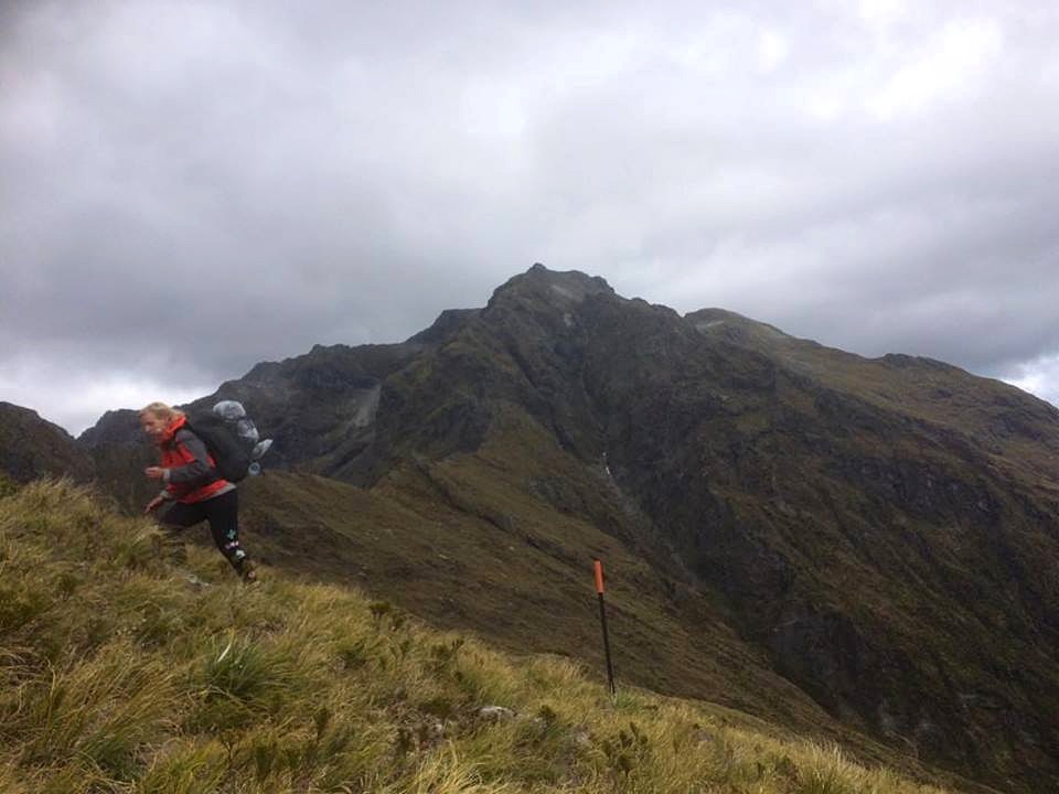
Up early, packed up it was time to hike up, up and yep, up. In fact the aim of the day was to reach 1300 metres high. Certainly not the highest I’ve ever climbed so foolishly in my head I thought, how hard could this be?
Well, hard was an understatement. The path to Dore Pass valley is not well trodden, the markers are not always frequent – or present at all– the trail would disappear just as you got comfortable. Then it would be bush bashing and fighting against baby trees, cobwebs, ferns, climbing over fallen trees and hidden holes in the road.
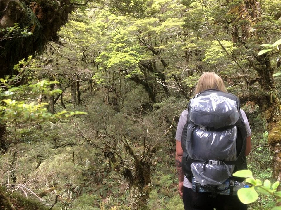
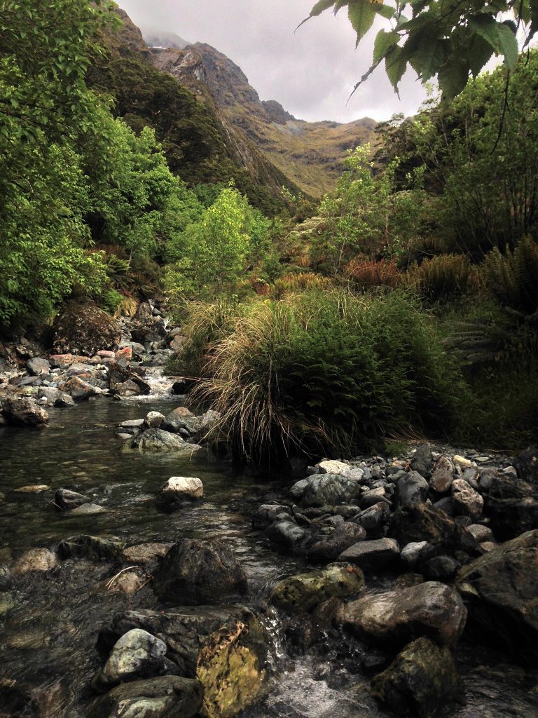
There was not another soul on the path in the morning. It was beautiful; the forest was quiet, the noises of creaking trees and singing bell birds with the occasional kaka song chiming in. I could hear calm running of the river in the valley below and knew we were close. After 2 hours of bush bashing and trail finding we – once again – lost the trail. So decided instead of fighting the ferns and marsh upwards, we dropped down to the river in the valley for a well deserved break.
Sitting in the rocks next to the flowing river, listening to the confident flow of the water and recharging.
Looking ahead the saddle was insight. It looked a lot higher than 1300 metres.
The only sign that we were heading in the right direction – and that other people had passed by here – was the cairn a little further down the creek. So of course we made our own one a little further up before crossing the river and heading back into the bush – for another battle.
The bush thinned out across the river. Small bushes, long grass and baby thorn bushes replaced the giant trees and heavy bush. The ground below, due to the rain was pretty wet, which made footing hard. Eventually we gave up trying to follow the river through the bush it was much faster hop rocking up the river.
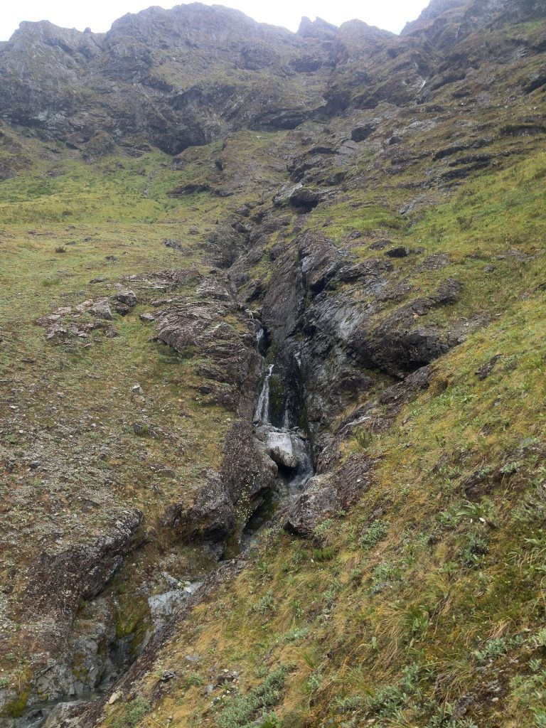
So focused on rock hopping. Captivated by the incredible and dramatic scenery around us we kept travelling up the river. All the way up the river until we hit the river’s version of a wall; a waterfall. A giant waterfall. Oops, we had gone a little to far but it was incredibly impressive to look at. This was one of the moments I truly appreciated how small we were compared to the landscape we found ourselves in.
Then we made a VERY wrong turn…
Dore Pass is called an advanced track for a reason. Lack of markings and directions. Throughout the trail there are absolutely no signs and in many cases, any markings or visible trail whatsoever.
The directions and knowledge of where to go from the creek was gathered from pieces of information from multiple different blogs. Not official sites and so the information was, vague, to say the least. We were looking for old snow poles, hopefully. The only one we could find was a way back down the river on the bend and the arrow attached either pointed across the river. Or to the left which would lead up higher above the river and across the waterfall.
The bush and wild grass pretty much reached the height of the now, orange-with-rust poles. Allowing them to really blend into the landscape.
From the river looking up, both routes seemed possible. Looking to the left of the waterfall however, seemed to offer a faint track up, lined with well rooted trees and shrub. We figured it was probably the fastest way to gain height and so set off up this ‘trail.’
Just as quick as the trail was below our feet it was gone. Once again we stopped, pulling branches from my hair, brushing off the mud from our freshly grazed skin due to the razor grass and thorny shrubs and re-evaluated.
Now where?
Well, the natural sheltered dip in the hillside seemed like the best route to follow. It wasn’t covered in this horrible bush and seemed to offer a fairly easy route up with minimal climbing – yep, climbing.
So up we went. All was fine until; Moss wall.
It wasn’t until Andy heaved himself and his pack up the wall and I tried to attempt to follow in his footsteps that I realised – after getting half way up and slipping back down, multiple times – this was not a trail, it was a ‘dried’ (but wet enough) up waterfall. Or in other words, a wrong turn and a bad place to be with rain on the horizon.
So why so bad, we could have just turned around at this point, head back down. Re-evaluate. I wish we did.
Getting up the first moss wall – after sliding down it 4 times – and covered in mud I shouted to Andy. He was further ahead, climbing the next horrible wall, swearing and agreeing with me but not turning around.
The last words I heard as he disappeared was; this climb is too hard. Climb to the trees, maybe we should go down!
And then he was gone..
So I tried to climb to the trees. Wrapping my hands around the shrub leaves and long grass I would try to get my feet into secure holds. But every time my weight plus my pack pushed on the moss, my feet would slide. So I waited for Andy to pop his head back through the bush letting me know the game plan. But nothing. I shouted, I couldn’t hear his normally reliable whistle. Nothing. I shouted louder, nothing again. Screaming, but still nothing…
Half way up a moss wall I was trying to stop my brain from panicking. Trying to decide whether to keep climbing to find my friend or slide down and go back to river. He had the EPIRB, was I actually in an emergency situation? I was still shouting. After about 15 minutes I heard a faint noise that mountains and wind definitely couldn’t make. A faint mention of river made me turn and slide down the wall I had just climbed, then, he came into view. Thank God.
Emergency over.
This is the most heart stopping/panicking fifteen minutes I have had while hiking, ever.
Sliding back down both walls (I had just climbed) on my butt, covered in mud and shrub, cuts and bruises, I didn’t care I just wanted down and back to the river.
Regrouped at the river. Spirits lifted with chocolate, water and knowing each other was safe we had no more time to rest.
The time we lost climbing the wrong way not only cost us valuable energy – we still had a 500 metre traverse ahead – but we were both painfully aware this was not the hardest section. In fact, from what we had read, the other side of the saddle was to be the most challenging. With the weather predicted for thunderstorms we wanted up and over, quickly.
The climb to the saddle on Dore Pass tested me, hard.
Now we knew the way (to your right from the waterfall, up the bush line if you’re looking at the saddle by the way) it was a relatively straightforward route to the saddle.
Straightforward but steep.
The first hour is pretty steep and after our wrong turn, I was fading fast and fighting a mental battle with each step forward. Dore Pass was testing me like I had never been tested before – dramatic, I know, but true.
The climb to the saddle was beautiful. The shrub thinned out, eventually reducing to tall grass growing ever shorter as we climbed higher. While looking ahead seemed daunting, turning around we were welcomed with breathtaking views. We crossed rock slides and as we climbed, scouted out the best way to cross the waterfall.
I imagine the ‘best way’ to cross will change depending on the rainfall from the last few days. Due to this, I don’t want to advise the ‘best way’. But we continued to follow the waterfall up until the ‘river’ was narrow enough to cross with a stride. A jump would have been a little to risky. A combination of wet ground, heavy packs and a slip that – if you slipped into the river flow – would most probably cost your life, was not worth the jump.
Snow Poles were in sight!
There is a faint trodden path from the opposite side of the waterfall to the false saddle. Marked with snow poles! Success! Finally markers to fill us with confidence in our route. Andy powered ahead of me. I was still battling, slowly pulling myself up the steep route.
Reaching the false saddle rocks, and looking back down the valley all I could think was; Wow this view is beautiful, but Jeez, we have had a big day – and it was nowhere near finished.
Only Four Snow Poles to go until the Saddle.
Now Three. Two. Almost there!
Each snow pole was a goal. We would both stop, Andy would wait for me, we’d take a moment to appreciate how far we had come and then move on. The closer to the saddle the dryer the ground became. Which would also now crumble beneath our feet.
If you are carrying a heavy pack – like us – hold onto the shrub. It is an incredibly steep traverse and sliding down would force you down far.
Reaching the saddle, I carefully dumped my back in the sheltered cover below and climbed onto the edge. WOW. The view, the wind, just everything at that moment was incredible! Dore Pass at this moment, was so beautiful.
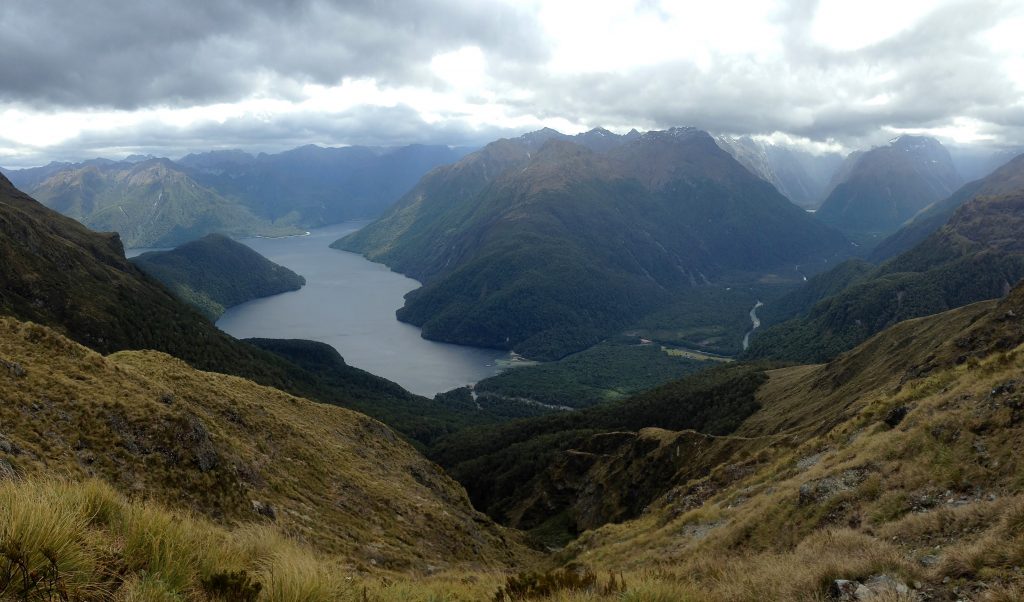
On the far side of the saddle, was the beautiful Lake Te Anau and the start of the Milford Track. The other side, the route we had just come.
Downhill all the way, baby!
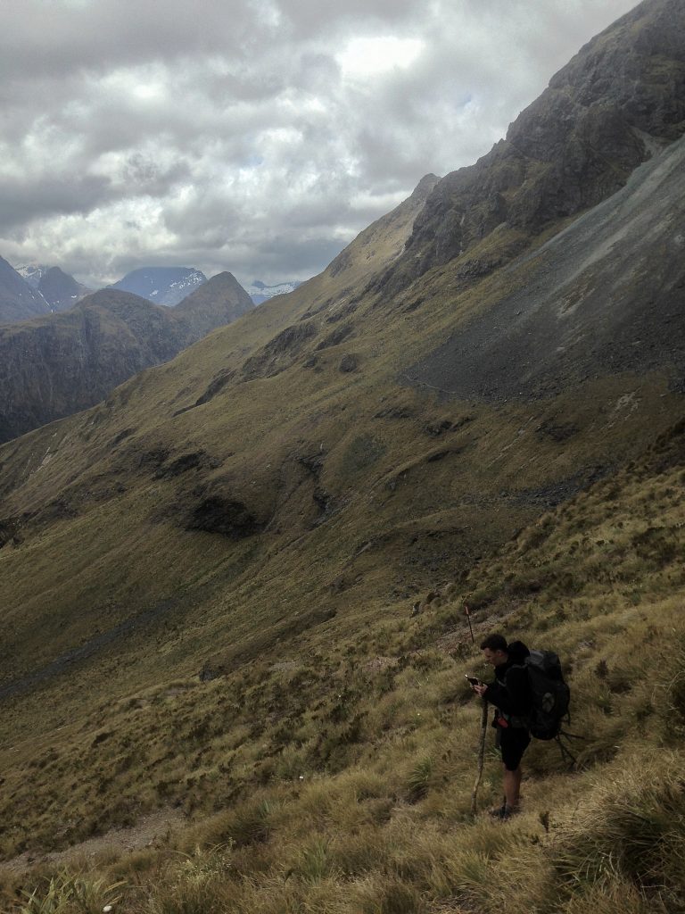
Snow Poles lined the mountain side, clearly visible on this beautiful day, showing us the way down.
From everything we had read before undertaking this hike; downhill on Dore Pass was the section of the hike people were most concerned about. I couldn’t really see why.
From the saddle, check the time and make sure you don’t descend for around 45 minutes. The Snow Poles will keep you right, but sometimes trails appear, trying to direct you down. Don’t follow these, they will lead you to bluffs and you’ll just have to turn around and head back up.
It’s a relatively easy walk but it requires all your attention, careful footing and alpine knowledge.
Crossing landslide areas, old and new rock fall, at one point the route round a rock was so tight, some serious rock hugging happened; which is not easy with a big heavy pack strapped to you. In some parts sliding would be a LONG way down. I’m glad I undertook Dore Pass with a partner at these points.
Directed by the snow poles and almost bang on forty-five minutes we began to descend. Taking moments to stop and enjoy the view, rest, drink and eat (chocolate) knowing the hard hiking was behind us. The previous struggle became a distant memory.
Down, Down, Down…
From Alpine mountains, to bogland we entered the forest. Wet shoes from the bogs, but with little care we carried on down. It was great to be in the trees on our way down. We made a pact that once we reached the burn below it was humus and wraps all round!
You’ll be glad to know that once you leave the heights of the mountain the trail all the way to Glade House is incredibly well-marked. Plenty or orange arrows around, it would actually be hard to lose the trail now – clearly the forest is much more well ventured.
After what was hours, us and our aching knees and legs (and spirits) made it to the creek. I’ve never been so excited to refill my water, sit down for longer than 5 minutes and finally eat something more nutritious than just chocolate – although, chocolate was shared to.
With the storm clouds moving in, it was time to cheeky set up our tent, for our final night of camping.
Listening to the patter of the rain and the crash of the thunder it wasn’t long before we both fell asleep. Exhausted from the days epic journey.
The Dore pass track ends at the start of the Milford Track – Glade Hut. Here we waited out the worst of the weather before hopping on the boat back to Te Anau downs.
Dore pass will forever sit up there with one of the hardest and beautiful hikes I’ve ever done. When my friends ask me about this and specifically whether I would recommend it… I have to pause and think.
It’s a hard hike and while I would recommend it for those up for a challenge in the wilderness. Dore pass is definitely not for the day walkers looking for easy climbs with beautiful views.
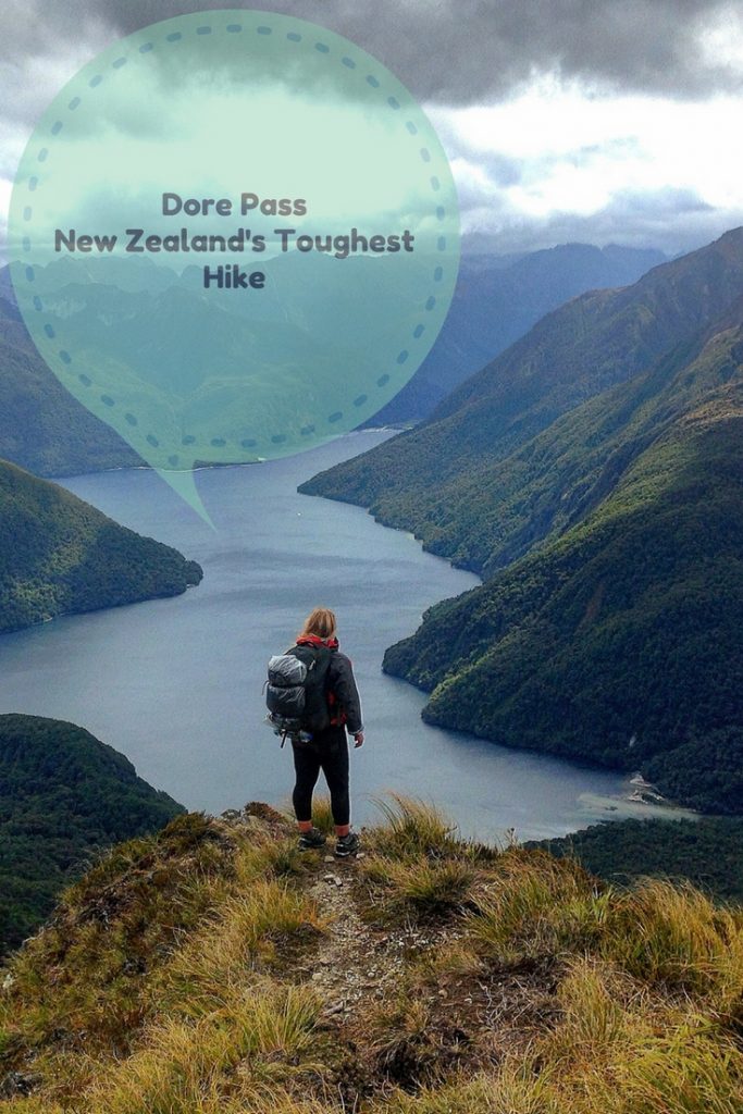
Like this article? Pin it on Pinterest and share one of the most awesome, yet tough hikes in New Zealand!
8 thoughts on “Dore Pass: Fiordlands Toughest Hike”
Badass.
Thanks girl!
Pingback: New Zealands Best Hikes for Adventurers - Little Wanderlust Stories
Hi i am constant visitor of your site.I always find some thing new here. There one more site Flightsservices.com which resembles you. But some functionalities are unique there. As fan of your wesite want such functionalities here too.
Thank you!
Thanks for giving such a wonderful information. It is very helpful.
Have you done Rainguage Spur in the Tararuas? Just wondering how it compares?
I have never done that, so I can’t compare sorry!